
Did you know that Wisconsin is home to four beautiful National Parks and National Scenic Trails?
They are visited by more than half a million people each year, and they add tens of millions of dollars to the state’s economy.
In this article, you’ll find general information about each National Park and scenic trails in Wisconsin, plus can’t-miss stops in each one.
Fun fact: The National Park Service preserves more than 826,000 artifacts in their museum collections in Wisconsin.
1. Apostle Islands
Overview
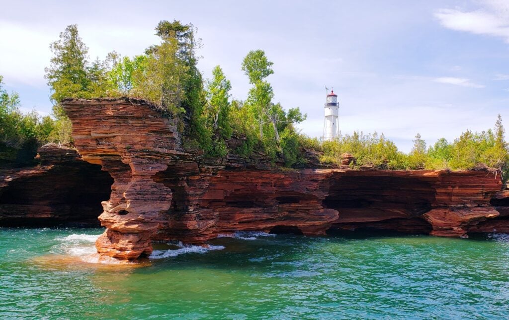
Perhaps the most famous of all the national parks and trails in Wisconsin is the Apostle Islands National Lakeshore, a coastal park located on the northeastern tip of the Bayfield Peninsula, brimming over with natural beauty.
The Apostle Islands are located in Lake Superior, the Great Lake known for its frigid temperatures, rough seas, and heavy fog. (Boaters beware of changing conditions!) Despite the conditions, black bears have been spotted swimming from island to island!
Although it is open year-round, the islands become challenging to access during the colder half of the year. The winter weather can be very cold and extreme.
In the summer months, the temperatures run in the mid-60’s to upper 80’s. In the Spring and Fall, temperatures fall to the forties and fifties, and in the Winter, everything is frozen over.
Known as the Jewel of Lake Superior, there are 21 separate islands and a 12 mile mainland unit.
Meyers Beach is a good place to access the park on the mainland, especially if you’re making a quick trip or have limited time.
Located 17 miles west of Bayfield off Highway 13, there is a day use parking fee to use the parking lot with picnic tables, vault toilets, and access to recreational opportunities, a trailhead to the Lakeshore Trail, and a staircase leading down to the beach.
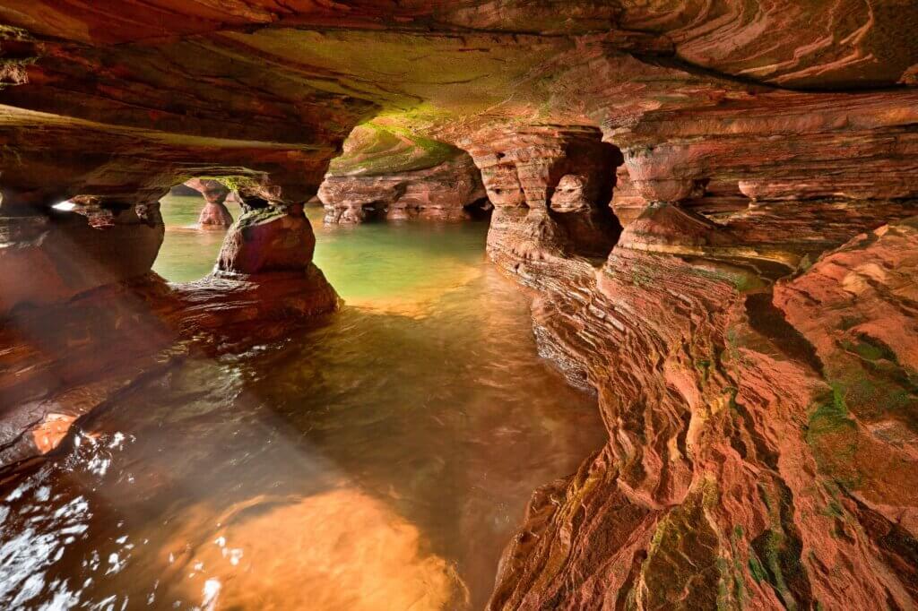
From Meyers Beach, families can launch a kayak and paddle out to the sandstone sea caves (created over centuries of waves and freezing and thawing), and experienced hikers can brave the Lakeshore Trail to see the sea caves from above.
The Lakeshore Trail provides an ideal spot for views of not only the sea caves, but also hardwood forests and Lake Superior. However it can be demanding with rugged paths and steep slopes.
You can also take a guided cruise with Apostle Islands Cruises, or go on a sailing expedition to see the rocky shoreline from the water.
Nature lovers will not be disappointed in this popular destination.
Take a ferry to Madeline Island, where no cars are allowed. Bikers will love cycling around the island, and hikers can explore hiking trails in the Madeline Island Wilderness Preserve and Big Bay State Park.
Big Bay State Park boasts a mile and a half of sandy beaches, campground, picnic areas and more than seven miles of hiking, boardwalk and nature trails. Within the park is a 440-acre sand spit and bog.
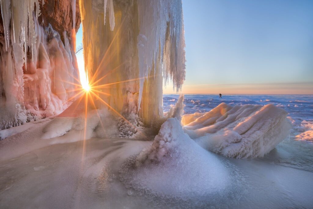
During the winter months, if the ice conditions are safe you can access the ice caves by walking on frozen Lake Superior.
No public WiFi is available at park facilities, but you can get good cellular service in Bayfield, Washburn, and Ashland. Cellular service on the island is not reliable.
Visitor Centers
The Bayfield Visitor Center is located in the old Bayfield Courthouse Building, an iconic, brownstone building on Washington Ave. There are museum exhibits, a park film, a bookstore, and you can get information and camping permits there. It’s open every day except holidays from 8:00 – 4:30.
New in 2020, The Little Sand Bay Visitor Center is home to exhibits that tell the story of living in the North Woods. You can also see the recently restored Twilite Fish Tug, a 36 foot vessel built in Bayfield in 1937.
The Stockton Island Visitor Center is also open seasonally during the summer month with rangers available to answer questions or assist in emergencies.
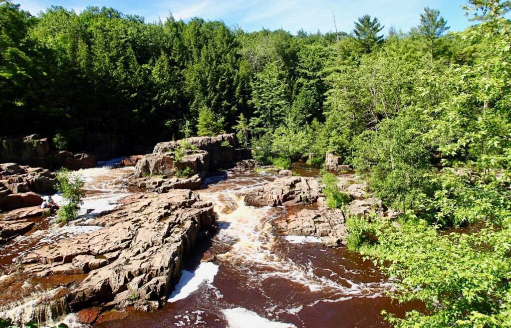
Amnicon Falls State Park
Amnicon Falls State Park is a nice side trip for those visiting the Apostle Islands. It’s home to several waterfalls and rapids, located along the Amnicon River 15 miles east of Superior. You can view them from a covered foot bridge or 2 miles of trails along the river.
You can picnic, camp, or walk in the woods to learn about the tremendous Douglas Fault, the geological formation that created the falls.
Visit the National Park Service website for more information.
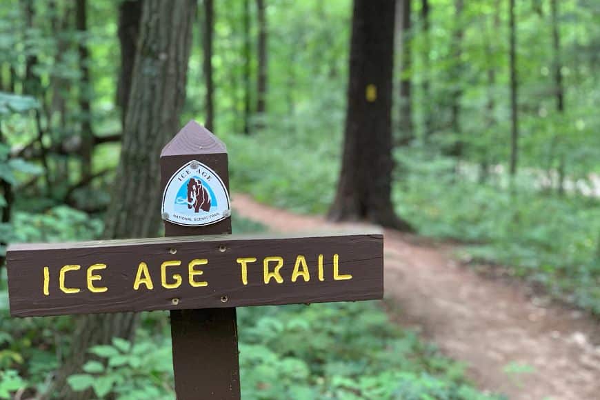
2. Ice Age Trail
Established in 1980, the Ice Age Trail is not a typical national park. It’s a 1,200 mile trail that traces the edge of a huge glacier that existed thousands of years ago.
Fifteen thousand years ago during the ice age, most of North America lay under a huge glacier while mammoths and saber tooth cats roamed Planet Earth.
Wisconsin is home to some of the best evidence of this glacier with its Great Lakes, small lakes, river valleys, rolling hills and ridges.
The best way to see proof of this glacier today is to hike the Ice Age Trail. The 1,200 mile Ice Age National Scenic Trail traces the glaciers edge and criss-crosses through northern and southern Wisconsin from east to west.
Different segments of the trail are managed by the National Park Service, the State of Wisconsin, county forests, and private landowners.
There are trailheads and access points located in many places along its hundreds of miles of trails. Recreation areas along the trail allow visitors to go hiking, mountain biking, cross country skiing, and even horseback riding on the trails.
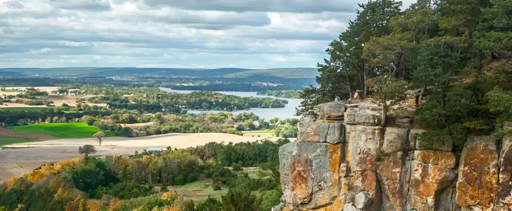
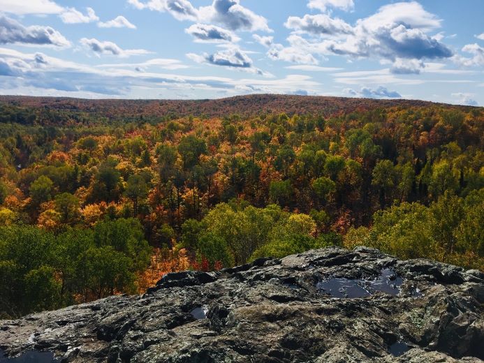
One of the most impressive vistas along the Ice Age Trail is Gibraltar Rock in Columbia County, located on the trail about 45 minutes north of Madison, WI.
It’s a flat-topped butte that rises 1,234 feet above sea level, its 200 foot cliffs offering panoramic views of the Wisconsin River valley and Lake Wisconsin. After a hike of just over a mile, hikers will climb a series of 50 steps that lead to the top of Gibraltar Rock.
You also may want to check out Timm’s Hill Trail, which leads to the highest point in Wisconsin.
Some of the most popular sections of the Ice Age Trail are located in Sauk County, in and around Devil’s Lake State Park.
The National Park Service does not charge a fee to enjoy the Ice Age National Scenic Trail, but some state and county parks located along the Trail may charge entrance fees.
Cellular Access along the Ice Age National Scenic Trail can be intermittent or unavailable in remote areas.
Visit the National Park Service website for more information.
3. North Country Trail
The North Country National Scenic Trail runs through 8 states from Vermont to North Dakota, including northern Wisconsin.

The Western Wisconsin segment runs from the Minnesota/Wisconsin State Line to Bayfield County A. This segment offers mostly flat trails and gentle slopes with some expansive vistas.
You’ll see old growth groves of red and white pine trees and in the late summer the prairies are abundant with flowers. There are many streams along this segment and the eastern part of this segment runs along small, pristine lakes.
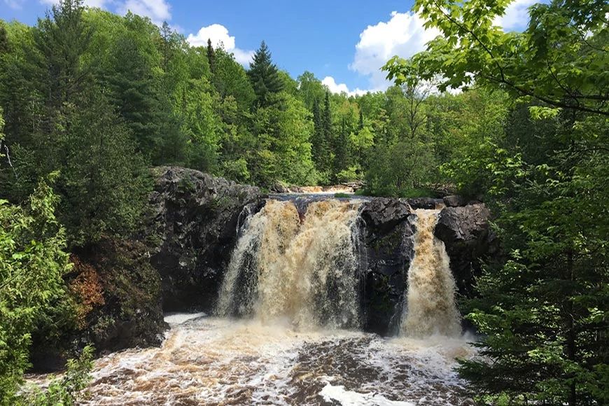
Along this segment you’ll find Pattison State Park, which features the highest waterfalls in Wisconsin and fourth highest waterfall east of the Rocky Mountains. Big Manitou Falls is 165 feet high and Twin Little Manitou Falls is 31 feet high.
The oldest section of the Trail in Wisconsin is the Chequamegon National Forest, running from Bayfield County A to the Sandstone Ledges Spur Trail in Copper Falls State Park.
The trails pass through gentle terrain and two federally designated Wilderness Areas: Porcupine Lake Wilderness and Rainbow Lake Wilderness, both popular with visitors.
The Juniper Rock Overlook offers a showstopping view in the Chequamegon-Nicolet National Forest, located along the North Country Scenic Trail. It’s rated as moderate to difficult because it is rocky and steep at times. However the hike is only a half a mile, which means it will only take you about 20 minutes to complete. At the end of the hike, you’ll be rewarded panoramic vistas of the Marengo River Valley. If you continue on, you can hike over a bridge over the Marengo River Valley.
In the Eastern part of the state, the Trail continues through the “land of waterfalls” and rocky outcrops of the ancient, worn down Penokee Mountain Range. This segment of the Trail is more wild and arguably more breathtaking, with expansive vistas.
In this segment, the North Country Trail runs through Copper Falls State Park, a waterfall heaven. The doughboys Nature Trail is a 1.7-mile trail that that offers spectacular views of Copper Falls, Brownstone Falls and the Tyler Forks cascades.
No fees are charged for hiking on the trail but fees may be required for parking, camping, or entrance at various sections along the trail.
You’ll find historic sites along the way with information about the landscape, Native Americans, national historic landmarks and important people. Visit the National Park Service website or the North Country Trail Association to plan your trip.
4. Saint Croix National Scenic Riverway
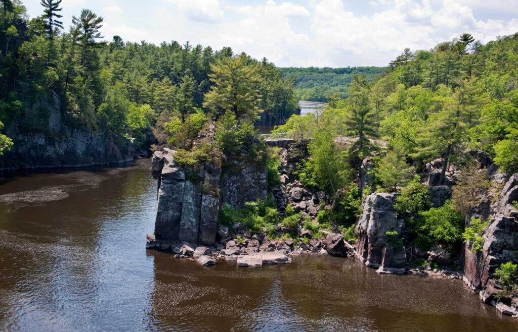
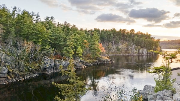
The St. Croix National Scenic Riverway is the largest scenic river way east of the Mississippi River, and it offers more than 200 miles of clean water rushing through a stunning forested landscape, deep gorges, and rock formations. The St. Croix and Namekagon rivers form this picturesque riverway.
Families can kayak at Norway Point Landing or the Namekagon/St. Croix confluence, snorkel at Cable Wayside, take a paddle boat on the St. Croix River, float the Big Bend of the Namekagon, paddle the Kettle River Slough, fish, hike, and stroll through historic towns along the way.
In early spring, temperatures reach the 40’s, and the melting snow and ice causes high, fast, and frigid waters. Summer temperatures get up in the mid 80’s with severe weather possible throughout the season.
The gorgeous fall colors being in late September and early October, with temperatures in the mid 60’s. The scenic rivers being to freeze over in December, and the winters are well below freezing.
Entrance to the national park visitor centers, facilities, and land is free.
The Namekagon River Visitor center is located near the Namekagon River off Highway 63 in Trego, Wisconsin. It’s available for viewing exhibits, perusing park publications, picking up Junior Ranger booklets and maps, and watching a park movie. Park Rangers are available for trip planning assistance.
The St. Croix River Visitor Center is also located along the St. Croix River with exhibit, park publications, trip assistance, and more.
The City of St. Croix Falls is a historic river town located along the St Croix River in western Wisconsin. It’s known as the City of Trails because it has access to the Ice Age Trail, the St. Croix National Scenic River Way, and more.
No public WiFi is provided in the park. Cell service is often limited in the river valley.
Visit the National Park Service website for more information.
Who knew that Wisconsin is home to some of the most beautiful national parks in the United States?
From the Apostle Islands in the very north of the state to the southern most portion of the Ice Age Trail, Wisconsin is home to a rugged natural beauty that will impress even the most experience of hikers and outdoor enthusiasts.
The state’s natural wonders don’t stop at the its national parks.
Wisconsin is also home to impressive state parks including Peninsula State Park (the state’s third largest), Lakeshore State Park in downtown Milwaukee, Copper Falls State park (home to a waterfall that falls over ancient lava flows), High Cliff State Park (located on the state’s largest lake, Lake Winnebago), Mirror Lake State Park (with cliffs up to 50 feet high), and more.
If you’d like to explore Wisconsin State Parks within a couple hours of Milwaukee, we put a list together of some of the best state parks to visit in the badger state, including Aztalan State Park (home to Wisconsin’s only ancient ruins), Harrington Beach State Park located along Lake Michigan, Havenwoods State Forest (Wisconsin’s only urban state forest), Kettle Moraine State Forest, Kohler Andrae State Park, are more.
We also have a list of historic lighthouses that families can visit seasonally, including the North Point Lighthouse, the Wind Point Lighthouse in Racine, the Lakeside Park Lighthouse in Fond du Lac, Rawley Point in Two Rivers, and more.


